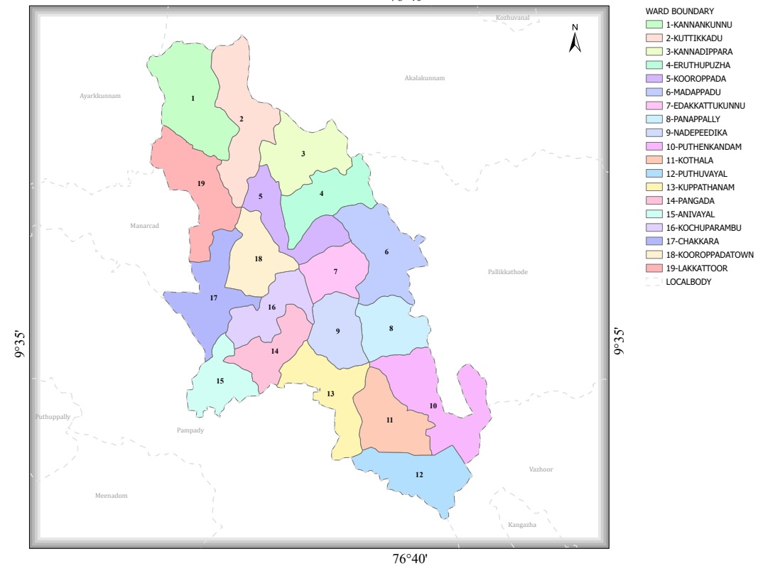
Geographical Map
Kooroppada Grama Panchayat – Ward Delimitation Report
1. Introduction
As per the order issued by the Kerala State Delimitation Commission on 15 May 2025, Kooroppada Grama Panchayat has been divided into 19 constituencies (wards). This delimitation was carried out based on the decision to fix the number of members to be elected through direct election to the Grama Panchayat at 19.
2. Key Findings
- The Grama Panchayat has a total of 19 wards.
- Clear geographical boundaries have been determined for each ward.
- The population of the wards ranges approximately from 1,283 to 1,639.
3. Wards and Population
| Ward | Population |
|---|---|
| Kannankunnu | 1,424 |
| Kuttikkad | 1,455 |
| Kannadippara | 1,492 |
| Eruthupuzha | 1,470 |
| Kooroppada | 1,593 |
| Madappadu | 1,538 |
| Edakkattukunnu | 1,317 |
| Panappally | 1,507 |
| Nadappeetika | 1,596 |
| Puthenkandam | 1,535 |
| Kothala | 1,630 |
| Puthuvayal | 1,639 |
| Kuppathanam | 1,532 |
| Pangada | 1,335 |
| Anivayal | 1,360 |
| Kochuparambu | 1,283 |
| Lakkara | 1,375 |
| Kooroppada Town | 1,409 |
| Lakkattoor | 1,486 |
4. Analysis
Population Distribution
- Ward with the highest population: Puthuvayal – 1,639
- Second highest: Kothala – 1,630
- Ward with the lowest population: Kochuparambu – 1,283
Administrative Significance
- The ward delimitation aims to ensure a balanced distribution of population among the wards.
- It helps provide equal political representation to different areas of the Panchayat.
- The new division will help implement future development projects, infrastructure development, and welfare programmes more efficiently.
5. Conclusion
The new delimitation of 19 wards in Kooroppada Grama Panchayat has been designed to ensure balanced representation based on population. The reorganisation is expected to improve administrative efficiency and make local development activities more effective.